
Document Content
Daily Log
July 11, 1972
Rectangle 5
Continued cleaning the stones that appeared yesterday in grid G/3. Two finds in stratum containing carbon (B) on level of stones\' upper surface:

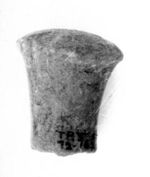
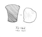 19720162
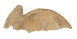
- Find #1
- F-G/3 (B)
- Rocchetto, ab. half preserved
Decided not to work further down in this area around the stones for the moment.
When polishing "red area" ( see map on p. 12 ) visible as a strip through grids J-F-G/1-2, we noticed how it seemed to be in line with the western side of the N-S wall of the lower buliding cleared by E.N. in courtyard area to the south. The hard grayish "galestrose" soil in connection with it might be part of same feature; the width of this gray, along with the red strip, was traced northwards and showed up well in a low-cut E-W section in G-H/2-3.
If this really is the same wall in its continuation northwards, it is remarkable that it is preserved
to such a height. When going down further into a lower level, this will more easily be ascertained.
This means that the red strip including the gray (=mudwall's interior part) shouldn\'t be removed, at least not at this stage of digging.
In grid I and J/2-3, we started going down through the burnt stratum, the upper surface of which over this area was noted before. After about 10 cm, a somehwat harder surface, partly colored light red, appeared, noticeable esp. in J/3. The soil contained carbon, was of a yellowish/red/black color.
Ab. 1 box of tiles from the area (not a compact tile layer) and not very much pottery, but some very fine pieces (bucchero), most of them from approx. area where grids J/2, J/3, I/2, and
I/3 meet.
 19720389

 19720395
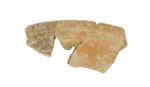
- Find #3
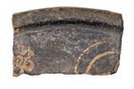
- Two fragments, not joining, of bucchero rim with plastic beans
 19720382
- Find #4
- Two fragments, joining, of bucchero rim with double guilloche pattern

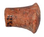
 19720388
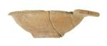
- Find #5
- Low small cup of bucchero, whole profile pres.
 19720384
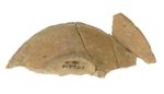
- Find #6
- Small cup, three joining fragments, redburnt bucchero
All these sherds were found on approx. depth of +30.05 (level measured with the instrument by Hans).
A few pieces of a thickness ab. 1 1/2 cm were left in situ in J/3, on top of the distinct redburnt surface here. It is still not clear if this burnt surface is a pavement level.
It is remarkable that this type of pottery which indicates "lower building" was found in so high a level.
When finishing off this area towards west in grid J/2, we found a frieze cavetto frag. in connection with mudbrick/wall plaster area in J/2. The mudbrick/wall plaster area here might belong not to upper pres. part of N-S wall of lower building but rather to upper crosswall between Rect. 6 and 7 or fill in foundation trench cut for this crosswall.
 19720387
- Find #1
- I-J/0-1
- Str. A
- Small bucchero fragment with stamped flower; upper surface gray, lower surface reddish brown
At this point, the trench might be called complicated.
It was not decided to make a 1 m wide cut E-W through grids I/0-3 starting from N-S wall of upper building, with the purpose of defining the relation between the stone fill of the pavement in 0, the mudbrick (mud) wall (?) in 1/2 and the burnt stratum in 2/3.
The stonefill lifted in I/0-1 was ab. 20 cm thick, compact, containing very little tile and pottery frags. the fill finished eastwards right where the "red area" showed up on previously dug surface in a N-S line in the middle of I/1, as indicated on map on p. 12 .
Immediately below the stonefill, we got into a strikingly redburnt stratum
in which, from about 5 cm down, big fragments of pithos and tiles turned up. Also, in I/1, part of the upper wall of a pithos appeared, perhaps in situ. In this level, along line defining red area westwards were irregular stones running approx. N-S, with some clayey soil visible in between, indicating probable line of wall. Possibly we have struck west side of N-S wall of lower building cleared by E.N. in courtyard in its continuation northwards, as supposed before.


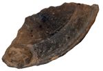
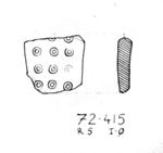 19720415
- Find #10
- I/0
- Redburnt stratum
- Fragment of redburnt bucchero handle with lines of stamped cocentric circles
| Descriptive Attribute | Value(s) |
|---|---|
| Document Type | Trench Book Entry |
| Trench Book Entry Date | 1972-07-11 |
| Entry Year | 1972 |
| Start Page | 20 |
| End Page | 36 |
| Title | Daily Log |
| Descriptive Attribute | Value(s) |
|---|---|
|
Is Part Of
Vocabulary: DCMI Metadata Terms (Dublin Core Terms) |
ER II
Vocabulary: Murlo |
Suggested Citation
Eva Rystedt. (2017) "ER II (1972-07-11):20-36; Daily Log from Europe/Italy/Poggio Civitate/Tesoro Rectangle/Tesoro Rectangle 5/1972, ID:435/PC 19720162". In Murlo. Anthony Tuck (Ed). Released: 2017-10-04. Open Context. <https://opencontext.org/documents/9fd127fa-158f-429f-bcb4-6f5c985818d7> ARK (Archive): https://n2t.net/ark:/28722/k2w95g22b
Copyright License
To the extent to which copyright applies, this content
carries the above license. Follow the link to understand specific permissions
and requirements.
Required Attribution: Citation and reference of URIs (hyperlinks)
