Image Preview: Drawing d-gen-039
| Descriptive Attribute | Value(s) |
|---|---|
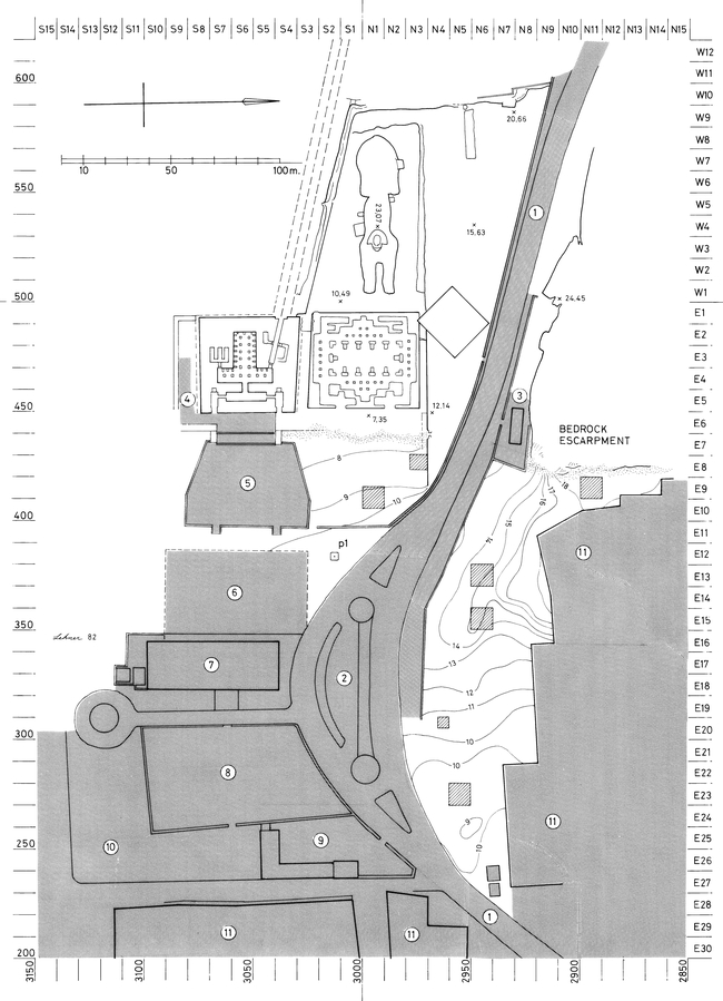
| Description | Figure 1.7. Map of modern installations north and east of the Sphinx with Hawass 1978 and 1980 excavation squares. The point "p1" is the location of 1980 core drilling. Map shows modern installations and features east of th Sphinx as of 1980. Compiled fromd-est-001, d-est-oo5, d-est-006. Grid, coodinate values, and square designations superceded by GPMP grid after 1984. |
| Image Type | Dissertation Figure |
| Year (Note) | 1980s |
| Resource Type | Drawings |
| Keywords | |
| Scale | 1:1000 |
| Creator | Mark Lehner |
| Dissertation Page Links |
| Descriptive Attribute | Value(s) |
|---|---|
|
Subject
Vocabulary: DCMI Metadata Terms (Dublin Core Terms) |
|
Suggested Citation
Mark Lehner. (2017) "Drawing d-gen-039 from Africa/Egypt/Giza/West of Khafre Valley Temple". In ARCE Sphinx Project 1979-1983 Archive. Mark Lehner, Megan Flowers, Rebekah Miracle (Ed). Released: 2017-12-23. Open Context. <https://opencontext.org/media/4288445c-d1f8-41c6-b9ce-7c877f678bd6> ARK (Archive): https://n2t.net/ark:/28722/k20g3wh21
Editorial Status
●●●○○Part of Project
Copyright License
To the extent to which copyright applies, this content
carries the above license. Follow the link to understand specific permissions
and requirements.
Required Attribution: Citation and reference of URIs (hyperlinks)
