
Document Content
Daily Log
Monday
AM
Began cleaning trench from severe weather that occured over the last week. The floor was swept and the baulk wall between loci 5&3 defined. Then locus 3 was excavated down to the same depth as loci 4&5. Also, the majority of the roots were removed. Unlike the excavation of locus 1, where a soil change was detected and loci 2&3 were created, no soil change was detected in locus 3 from the surface to the approximate depth of 65cm. This is probably due to the intense amount of roots in the soil and the dampness from a week of rain. The closing depth for locus 3 was approximatley 65cm abd then loci 3&5 were conflated into locus 6 since both had the same crumbly gray-olive soil and the roots no longer interfered with excavation of that area of the trench. The following points were taken for locus 6:
Coordinates(m) Depth(cm)
1. 51.40S 160.74E 62
2. 51.35S 160.63E 68
3. 51.91S 160.90E 65
4. 53.04S 160.09E 65
5. 53.63S 161.40E 59
6. 53.50S 160.64E 65
7. 52.22S 161.36E 62
Also, a formation of stones was noticed and included on locus form #15 and rendered on a map (p. 39)
PM
The coordinates and diameter of the stones in the map are the following (the average depth was approximately 65cm):
Coordinates(m) Diameter(cm)
1. 51.36S 160.42E 15
2. 51.86S 160.56E 16
3. 51.56S 160.30E 20
4. 52.16S 160.49E 18
5. 52.46S 160.56E 20
6. 51.31S 161.25E 13
7. 51.65S 161.07E 17
8. 52.08S 161.05E 30
9. 53.70S 160.50E 33
After the map was finished, the baulk walls were trimmed, the floor levelled, and cleaned. This process took the entire afternooon due to the extremely muddy state it was in. From locus 3 approximatley 1 full latte box of bulk pottery was found and a 1/4 cassetta of terracotta. Plus, the following special finds were made:
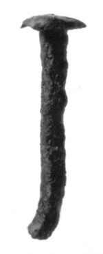 20000035
- Find #1
- 52S 161E Locus 3
- Depth of approximately 56cm
-
Heavily corroded nail

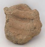
 20000027
- Find #4
- 51.29S 160.78E Locus 6
- Depth of 65cm
-
Lateral sima cavetto fragment
| Descriptive Attribute | Value(s) |
|---|---|
| Document Type | Trench Book Entry |
| Trench Book Entry Date | 2000-07-17 |
| Entry Year | 2000 |
| Start Page | 41 |
| End Page | 46 |
| Title | Daily Log |
| Descriptive Attribute | Value(s) |
|---|---|
|
Is Part Of
Vocabulary: DCMI Metadata Terms (Dublin Core Terms) |
SJG II
Vocabulary: Murlo |
Suggested Citation
Scott J. Glenn. (2017) "SJG II (2000-07-17):41-46; Daily Log from Europe/Italy/Poggio Civitate/Tesoro/Tesoro 21/2001, ID:446". In Murlo. Anthony Tuck (Ed). Released: 2017-10-04. Open Context. <https://opencontext.org/documents/a495068b-97ae-46dd-ab4f-d609c29b08a3> ARK (Archive): https://n2t.net/ark:/28722/k2m333n1m
Copyright License
To the extent to which copyright applies, this content
carries the above license. Follow the link to understand specific permissions
and requirements.
Required Attribution: Citation and reference of URIs (hyperlinks)
