
Document Content
Daily Log
July 17, 2001
AM
We began the morning working in locus 1 meters 35N, 170E through 35N, 172E (see plan for meter designations), and locus 2 as defined on page 17. A 5cm pass was cleaned up in locus 1 and another 5cm pass was made in meters 34N, 170E 34N, 172E. A large number of rocks became visible in these passes and they apeart to be bedrock. We may be reaching the level of unexcavated soil but currently we are still in fill. A pickpass was made and cleaned in locus 2 in meters 32N, 170E 32N, 170E. The rock feature in this area was farther defined and a large amount of pottery and tile has been recovered. Due to the amount of finds and their placement in the soil, I believe the locus 2 is previously unexcavated. Locus 3 was also definted today (see below).
PM
We continued to excavated both locus 1 and 2. Another pass was made in meters 34N, 170E 34N, 171E of locus 1. This area of the locus sloped quite a bit, so our primary goal is to level the slope in those meters to the level of locus 1 in the 35N, 170 35N, 172E meters. Again, a large amount of bedrock has surfaced in soil that appears to be fill by its tester, and the pockets of various soil throughout. Wile work was continued in locus 2, an area of tile concentration was
uncovered. The remainder of the day was spent defining around the tile concentration with baulk hammers and trowels. Totals for the day: locus 1 produced 1 latte box of pottery and bone and half a cassetta of terracotta and plaster. Locus 2 produced 1.5 cassetta of terracotta and tile and 2 latte boxes of pottery and bone. Most of the fragments in both loci are impasto and coarseware, but serveral find pieces of bucchero, buccheroid, and creamware did appear. Most of the terracotta of locus 2 came from the southern side of the rock feature. The soil dump for T-18 is about 30m to the east near T-17 and down the northern slope. The terracotta dump is also in this area.
LOCUS 3
Coordinates Opening depths
30.5N, 173E 88.1cm
30.40N, 173E 75.5cm
30.5N, 271.70E 87.8cm
31.25N, 272E 86.6cm
description: an area of excavated soil at a lower depth than that of locus 2 on the southern side of the rock feature
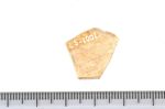
 20010057
- Find # 6
- T-18 Locus 2
- 85.5cm bd
- Painted Corinthian/Italo-Corinthian? And incised
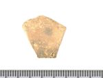
 20010070
- Find # 7
- T-18 Locus 2
- 81.4cm bd
- Incised buccheroid
| Descriptive Attribute | Value(s) |
|---|---|
| Document Type | Trench Book Entry |
| Trench Book Entry Date | 2001-07-17 |
| Entry Year | 2001 |
| Start Page | 18 |
| End Page | 27 |
| Title | Daily Log |
| Descriptive Attribute | Value(s) |
|---|---|
|
Is Part Of
Vocabulary: DCMI Metadata Terms (Dublin Core Terms) |
KLH IV
Vocabulary: Murlo |
Suggested Citation
Kristin L. Hostetler. (2017) "KLH IV (2001-07-17):18-27; Daily Log from Europe/Italy/Poggio Civitate/Tesoro/Tesoro 18/2001, ID:459". In Murlo. Anthony Tuck (Ed). Released: 2017-10-04. Open Context. <https://opencontext.org/documents/336afc27-f099-41d6-aca3-e7ee026f9976> ARK (Archive): https://n2t.net/ark:/28722/k2vq37p2k
Copyright License
To the extent to which copyright applies, this content
carries the above license. Follow the link to understand specific permissions
and requirements.
Required Attribution: Citation and reference of URIs (hyperlinks)
