Egiin Gol Survey
Intensive archaeological survey data from the lower valley of the Eg River in Northern Mongolia
Project Abstract
Overview of the Project
Then Egiin Gol Survey was a pioneering regional survey project in Northern Mongolia that both recorded data types never systematically recorded before in Eastern Eurasia and began the development of archaeological methodologies that have since expanded and developed across the Mongolia. Our survey work focused on the identification of habitation sites, the major innovative discovery of the project, as well as monuments and mortuary landscapes. Though it is very likely we have only detected a sample of those sites that have existed in the Egiin Gol valley, these data can be applied to a wide range of studies of the relationships of landscape resources and settlement areas in a pastoralist society, communities, modelling of seasonality and resource use, and to the relationship between monuments, burials, and settlement. These data also provide a regional comparison to examine settlement patterns and integration across larger regions. Our data spans c.25,000 years or human use of the Egiin Gol valley, offering a deep diachronic view centred around the Holocene, Bronze and Iron Ages, and historical lands of the last two centuries (table 1). In total 243 km2 were served and 604 separate archaeological locales recorded. The data available here complements the full publication of the survey (Wright, Honeychurch and Amartuvshin 2023).
Table 1. Chronological periods used by the EGS
|
EGS period |
Chronological Terms |
Date range |
|
Upper Paleolithic |
Late Upper Paleolithic |
32,000–14,000 BP |
|
Epipaleolithic and Early Bronze Age (EPEBA) |
Epipaleolithic, Mesolithic |
14,000–4000 BP |
|
Early Bronze Age |
2000–1800 BCE |
|
|
Bronze Age |
Middle Bronze Age |
1800–1400 BCE |
|
Late Bronze Age |
1400–1000 BCE |
|
|
Final Bronze Age |
1000–750 BCE |
|
|
Iron Age |
Early Iron Age |
750–250 BCE |
|
Xiongnu |
Xiongnu, Hunnu |
250 BCE–400 CE |
|
Turkic (Early Medieval) |
Early Türk |
400–750 CE |
|
Uyghur |
750–840 CE |
|
|
Later Medieval |
Khitan (Kitan, Kidan, Qidan) |
924–1125 CE |
|
Mongol Empire |
1206–1368 CE |
|
|
Historic |
1369–1700 CE |
|
|
Buddhist |
Manchu |
1700–1938 CE |
Geography
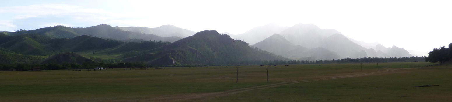
This project took place in northern Mongolia, along a major river in the Lake Baikal watershed. This region is in the transitional zone between the forested steppe and Siberian taiga forest. The forest along the Egiin Gol valley is a mix of pine, larch, and birch trees interspersed with glades of tall grass or shrubs that overlooks relatively open river valleys. The lower Egiin Gol valley is a landscape of narrow rocky ridges and high hills cut through by many rivers and streams that form steep-sided, flat-bottomed valley system. Elevation ranges from 850 m. at the lowest reaches of the river to 2000 m. at the tops of the highest hills. The main valley of the Egiin Gol is a series of terraces and bluffs rising from the river toward the ridges and forests. From forest edge to forest edge the valley is about 3 km wide at most
The Egiin Gol survey focused on the terraces and valley floor of a river and its tributary streams flowing through steep-sided valleys. The Egiin Gol itself is a fast-moving river running in a bed of gravel and cobbles. Fluvial features dominate the geomorphology of the lower Egiin Gol valley. The Egiin Gol is an under-fitted stream that formed terraces as it migrated back and forth across its valley floor. The active river floodplain itself is up to 2 km wide, with a lightly braided stream flanked by gravel and sand bars, and thin alluvial soils on the active floodplain. The tributary valleys encompassed by the survey are smaller versions of the larger river valley. The valleys are 0.5 to 1.5 km across and flanked by slopes, small terraces, and bisected fans with small under-fitted shallow streams of only c. 3-5 meters across. Though the immediate floodplain of the river remains active, major modifications of the valley and tributaries ceased with the end of the Pleistocene and most land surfaces have remained stable since then.
Significance
The Egiin Gol Survey was the first regional full coverage pedestrian survey carried out in Mongolia. The EGS made three fundamental advances in bringing to light the dynamism of the inhabited pastoral landscape of the steppe. First, the survey accomplished a “peopling” of the landscape that archaeologists had long considered inaccessible because of the mobility and presumed lack of material remains left by nomadic communities. Second, the diachronic view provided by regional survey showed that there was (and remains) a balance between continuity of space and place in inhabitation and adjustment and modulation in response to changing social and environmental conditions. Third, at the time the project was launched, scholarship rooted in ethnographic and historical data, offered descriptive models in which ancient pastoral nomads were seen as economically, technologically, and culturally dependent on sedentary societies. These ideas about nomadic communities were dominant in the research literature when we began our work, but in the end they were not supported by the Egiin Gol data. Our fieldwork revealed a contrasting narrative of dynamic organizational structure and local innovation which we now know is not unique to Egiin Gol, but is a common theme across the Eurasian steppe.
Overview of Data
The data here is made up primarily of information about artefacts scatters, the residues of dwelling on the landscape, and information about stone monument sites. Monument sites and rich monumental burials are the great charismatic archaeological objects of the Eurasian steppe. The prevalence of monuments make them key mechanisms of cultural transmission and social memory as well as defining elements of inhabited spaces.
The data here includes the following data sets (data descriptions to be written depending on tables):
Data tables
Site locations and characteristics
Individual stone monuments
Ceramics ware counts by site
Individual decorated sherds
Lithic counts per site
Excavations carried out by the EGS
Radiocarbon Dates
Geospatial data
Survey areas
Streams and rivers of the lower Egiin Gol
Relict field systems
Topographic maps of the LEGV
Modern herder’s campsite locations
Other data files
Individual ceramic illustrations (c. 600, can generate as a table with site locations?)
Site images (perhaps not… depends on how many I can get)
Interpretive Summary
The loess formations of the third terrace of the Egiin Gol — 10 m above current steam — have yielded the oldest evidence of human occupation in the valley, dating to the late Pleistocene and the last glaciation of Siberia. A small excavation here produced fauna and diagnostic large blade lithics from a time when the valley was periglacial tundra.
In the Holocene and terminal Pleistocene a mix of large and small scatters of Epipaleolithic flake and small blade industries are found clustered around the mouths of the tributary valleys of the Egiin Gol testifying to the stability of the valley systems. This is the first dense layer of archaeological data recorded, 40 sites of the East Asia microlithic tradition dating c. 10-3,000 years ago. None of our excavations helped refine this chronology or provided fauna for this critical period in human adaptation to the region so habituation locations — and some pottery — are the main guide to human activity in this critical time of incipient subsistence change.
The settlements of the first people buried with domestic animals overlap with the campsites of both modern nomadic pastoralists as well as Holocene foragers and hunters. There first herders dwelled in the Bronze and Early Iron Age, the golden age of monument building. It is in this period that the recording of archaeological material becomes dominated by the recording of monuments. There are 12 small artefact scatters associated with several centuries of time, but at least 324 monuments. Typologies of structures appear, are added to existing monumental and inhabited landscapes, and go out of use. This slow elaborate dance can be interpreted as one of changing identities and political forms as subsistence and power changed in the valley. The interrelationships of sites focuses interpretation on local internal dynamics played out on the most compelling canvas available, the monumental one. In addition to often fragmentary human remains, burials of this time contain horse, cattle, and sheep or goat bones, as well as bronze objects and horse-re-lated equipment. The organization and elaboration of satellite features, the erection of deer stones, and the addition of burials to non-mortuary monuments are all part of Bronze and Early Iron Age monumental construction and use. Few substantial single-period Bronze Age habitation sites were found by the EGS. Those artifact scatters that were identified were often intermixed with materials of other periods.
Many centuries of the Early Iron Age are enigmatic, but very clearly by the last centuries of the 1st millennium BC the old traditions of pottery and burial transitioned into new styles, built alongside existing older monuments suggesting centuries of continuity in the valley. Some habitation locations remained in use, but we detected new inhabited areas where houses were build and grains grown. Though there are 17 inhabitation locales, these include multi hectare scatters and productively excavated sites. The Xiongnu landscape, mortuary and settlement, is the clearest archeological period in the Egiin Gol. The survey of the Egiin Gol provided the first extensive view of inhabitation, burial and farming among everyday Iron Age inhabitants of northern Mongolia.
In the era of polities that followed the Xiongnu period, the Egiin Gol was part of the hinterland of administrative centers for empires the grew up in Mongolia. The Turkic and Uyghur periods are evidenced by inhabitation and burial record, continuing in the locations long used, but at a less scale than those before as the gravity of regional centers drew people closer to the their walls and into their economies. As continental scale empires spread from Mongolia in the medieval centuries, a centeral settlement grew up near the mouth of the Egiin Gol. Including humble examples of the elite architecture and glazed ceramics of the day. Around it several local cemeteries developed, some being build alongside monuments of the Bronze and Iron Ages and others highlighting new mortuary categories.
The final chapter revealed by our survey saw yet another reorganisation of the power and production in the landscape as irrigated field systems and Buddhist temples and monuments filled the valley. This religiously charged farming landscape is the last layer of the archaeological palimpsest of the Egiin Gol valley. Each layer was unexpected and dynamic but also easily linked to the inhabitation that came before through continuous use of common spaces and developments that existed within the frameworks laid down before them.
Methods
The Egiin Gol Survey was a full-coverage intensive survey supported by excavations that initially focused on collecting data on monumental and architectural features as well as artifact scatters. The survey area was defined by topography, geology, vegetation, and rivers. In total, an area of 243 km2, was systematically walked using different survey intensities — extensive and intensive approaches. Additional territory covered by a less systematic reconnaissance brought the total area to 388 km2. Because this project had no precedents in the region, we had little idea how best to define our survey area and intensity. Survey crews walked the landscape with 20 m between each person during the intensive survey portions and from 50 to 100 m in the extensive portions. A site-based recording design was used from the outset. This architecture focused method was adapted when during the first weeks of the survey a surprising number of artifact scatter sites were discovered.
The basic EGS site definition was five items within a diameter of roughly 20 m recovered in approximately five minutes of searching the ground. Everything we recovered was collected for analysis during the field season. At the few large and concentrated artifact scatter sites, we collected several kilograms of ceramics, but typical collections were a small number of items. Surface visibility was a critical issue during the Egiin Gol Survey. The three methods we used to check the effects of visibility on site detection were systematic shovel testing, the opportunistic examination of plowed tracts in portions of the survey area, and revisiting overgrown areas.
Architectural remains, earth features, and stone mounds were by far the most common type of site recorded by the EGS. We refer to many of these site types as “monumental” because of their size and patterned construction. This was also the common usage among Mongolian archaeologists. Our definition of a monument was a typological one: a feature or collection of features having a form known and recognizable to Mongolian archaeologists according to existing typologies.
The most basic unit of a monument site is a single monument of any size. However, in most cases multiple features are close together. These were grouped as a single site and the monuments designated with letters within the site. Monuments were grouped regardless of their potential chronological attribution; this preserves the final monumental palimpsest of each site as a possible focus of analysis. Each monument, except for some of the simplest types, was sketched as a plan at 1:200 or 1:400 scale.
A keyword system was developed for identifying sites in the field. Every site was given one or more typological keywords as it was recorded. Identifications and the parameters of each keyword were revisited during analytical studies. The final list for the Egiin Gol survey is shows on table 2.
Table 2. Site Keywords used but the EGS
|
Lithic scatter |
|
Sherd Scatter |
|
Metallurgical scatter |
|
Buddhist Stone |
|
Burial |
|
Enclosure |
|
Inscription |
|
Khirigsuur |
|
Monastery |
|
Mound |
|
Ring burial |
|
Rock art |
|
Slab burial |
|
Stele |
|
Stone alignment |
|
Stone feature |
|
Structure |
All EGS sites were numbered sequentially as they were found (i.e., EGS-001, EGS-002, EGS-003, and so on) regardless of type, size, or period. In some cases, sites also have names drawn from a nearby topographic feature, a convention in Mongolian field archaeology. In the case of the EGS, these names often encompass more than one EGS site number. During analysis a chronological tag was attached to the site number; for example, EGS- 036 became X-036 because it is a Xiongnu period site. Sites with multiple periods were given multiple chronological records (EGS-132 became E-132, B-132, X-132, and T-132). This increased the number of sites from the 542 locales initially recorded to 604 incidences.
For full details on the typology and methods see Wright, Honeychurch and Amartuvshin 2023.
Current Location of Collections
Material collected by the survey and recovered from excavations is stored at the Institute of Archaeology of the Mongolian Academy of Sciences and the Archaeology Center of the National University of Mongolia.
Publications
Amartuvshin, Chunag. 2003. ‘Egiin Gol Dakh’ Dorvoljin Bulshny Sudalgaany Zarim Asuudal [Some Questions Concerning the Slab Burials of Egiin Gol].’ In Mongol-Solongosyn Erdem Shinjilgeenii Ankhdugaar Simpoziumyn Iltgeliin Emkhtgel [Collected Papers of the First Mongolian-Korean Academic Symposium] , edited by C. Idshinnorov and D. Tseveendorj, 83–94. Ulaanbaatar: Mongolian National Museum, Academy of Sciences, Korean National Museum.
Crubézy, E., H. Martin, P. -H. Giscard, Z. Batsaikin, S. Erdenebaatar, J. P. Verdier, and B. Maureille. 1996. ‘Funeral Practices and Animal Sacrifices in Mongolia at the Uigur Period: Archaeological and Ethno-Historical Study of a Kurgan in the Egyin Gol Valley (Baikal Region)’. Antiquity 70: 891–99.
Hall, Mark, William Honeychurch, Joshua Wright, Zagd Batsaikhan, and Luvsanvandan Bilegt. 1999. ‘Chemical Analysis of Prehistoric Mongolian Pottery’. Arctic Anthropology 36: 133–50.
Honeychurch, Wiliam. 2015. Inner Asia and the Spatial Politics of Empire . New York: Springer.
Honeychurch, William, Joshua Wright, and Chunag Amartuvshin. 2007. ‘A Nested Approach to Survey in the Egiin Gol Valley, Mongolia’. Journal of Field Archaeology 32: 369–83.
Jaubert, J., P. Bertran, M. Fontugne, M. Jarry, S. Lacombe, C. Leroyer, E. Marmet, Y. Taborin, and B. Tsogtbaatar. 2004. ‘Le Paleolithique Superieur Ancien de Mongolie: Dorolj 1 (Egiin Gol). Analogies Avec Les Donnees de l’Altai et de Siberie’. In Section 6: Le Paléolithique Supérieur / The Upper Palaeolithic. General Sessions and Posters. Acts of the XIVth UISPP Congress, University of Liège, Belgium, 2-8 September 2001 , edited by Le Secrétariat du Congrès, 1240:225–42. BAR. Archaeopress.
Keyser-Tracqui, Christine, Eric Crubezy, and Bertand Ludes. 2003. ‘Nuclear and Mitochondrial DNA Analysis of a 2,000-Year-Old Necropolis in the Egyin Gol Valley of Mongolia’. American Journal of Human Genetics 73: 247–60.
Torbat, Ts., Ch. Amartuvshin, and U. Erdenbat. 2003. Эгийн Голын Сав Нутаг Дахь Археологийн Дурсгалууд, Egiin Golyn Sav Nutag Dakh’ Arkheologiin Dursgaluud, [Archaeological Monuments of Egiin Gol Valley] . Ulaan Bataar: Mongolian Academy of Science, Institute of Archaeology.
Wright, Joshua. 2007. ‘Organizational Principles of Khirigsuur Monuments in the Lower Egiin Gol Valley, Mongolia’. Journal of Anthropological Archaeology 26: 350–65.
———. 2011. ‘Xiongnu Ceramic Chronology and Typology in the Egiin Gol Valley, Mongolia’. In Xiongnu Archaeology, Multidisciplinary Persepectives of the First Steppe Empire in Inner Asia , edited by U. Brosseder and B. K. Miller, 5:160–68. Bonn Contributions to Asian Archaeology. Bonn: Vor- und Frühgeschichtliche Archäologie Rheinische Friedrich-Wilhelms-Universität.
Wright, Joshua, William Honeychurch, and Amartuvshin Chunag. 2009. ‘The Xiongnu Settlements of Egiin Gol, Mongolia’. Antiquity 83: 372–87.
———. 2023. Continuity and Authority on the Mongolian Steppe: The Egiin Gol Survey 1997–2002 . Yale University Publications in Anthropology 98. New Haven: Yale Anthropological Press. View on publisher's website.
| Descriptive Attribute | Value(s) |
|---|---|
|
Creator
Vocabulary: DCMI Metadata Terms (Dublin Core Terms) |
Joshua Wright
Vocabulary: Egiin Gol Survey |
Suggested Citation
Joshua Wright. (2017) "Egiin Gol Survey". Released: 2017-02-07. Open Context. <https://opencontext.org/projects/3d9b9ce0-47ee-40cb-ae94-046a056eb8b1> DOI: https://doi.org/10.6078/M7BR8Q4K
Editorial Status
●●○○○Copyright License
To the extent to which copyright applies, this content
carries the above license. Follow the link to understand specific permissions
and requirements.
Required Attribution: Citation and reference of URIs (hyperlinks)
