Architecture and Urbanism at Seyitömer Höyük, Turkey
Archaeology and chronology of Seyitömer Höyük, an Early Bronze Age - Middle Bronze Age settlement in western Anatolia.
Project Abstract
Overview
This dataset contains information about the archaeology and chronology of Seyitömer Höyük, an EBA/MBA settlement in western Anatolia. It is organized into two tables: (Table 1) Phase V-B Architecture and Space Syntax Values; and (Table 2) Radiocarbon Determinations and Chronology.
Table 1 contains records for each architectural space, and includes information about room dimensions, entrances, wall construction technique, floor construction technique, features, and in situ deposits, and space syntax values. Each record is linked to one or more photographs, a detailed room plan, and an Enhanced Access Graph.
Table 2 contains records for each radiocarbon sample selected for analysis. It includes paleobotanical information, the radiocarbon laboratory used for analysis, and the unmodelled date BP. It also expresses the results of a Bayesian statistical analysis, including posterior density estimates at 95.4% and 99.7% probability.
Period
This dataset dates to the Early Bronze Age (Phase V) and Middle Bronze Age (Phase IV) period in western Anatolia. The focus is Early Bronze III, and the transition to Middle Bronze I, which includes EBA Phase V-C, EBA Phase V-B, EBA Phase V-A, and MBA, Phase IV-A.
In 2014, 23 bone, seed and ceramic samples were sent to the Scottish Universities Environmental Research Center (SUERC) in Glasgow, Scotland. Ten of these samples were discarded because they contained insufficient dateable material; three samples failed, and ten produced a successful date. Later in 2015, 32 bone and seed samples were sent to the Oxford Radiocarbon Accelerator Unit (ORAU), in Oxford, England. Ten failed due to low yield; and 22 produced a successful date. The combined results of the SUERC and ORAU C14 determinations are summarized in this table:
| Phase boundaries | 95.4% probability |
|---|---|
| Phase V-A/IV-C | 2274 - 2220 B.C.E. |
| Phase V-B/V-A | 2281 - 2218 B.C.E. |
| Phase V-C/V-B | 2297 - 2226 B.C.E. |
Description
This project set out to achieve a better understanding of the timing, tempo, and character of sociopolitical changes in late third millennium BCE western Anatolia, by analyzing architectural and radiometric data from the archaeological site of Seyitömer Höyük. In pursuit of these goals, the project investigated the chronological extent of the Early Bronze III (EBIII) period, and analyzed how the architecture and spatial layout of the Phase V-B settlement (see plans here, here, and here)structured relations among institutions, elites and non-elites. The combined insights generated by this project improve our understanding of the fine-scale processes of daily life in an early urban environment, shed light on the archaeology of the poorly understood inland western Anatolia region, and contribute to archaeological heritage preservation at a threatened archaeological site.
The data archive presented here encompasses the results of the Ph.D. dissertation. Other publications that draw on the dataset include:
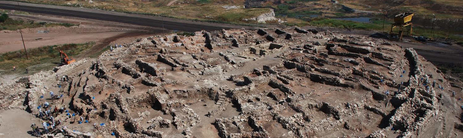
A series of intensive salvage excavations carried out by Dumlupinar University and the University of Buffalo from 2009-2014 revealed five cultural layers that span the Early Bronze Age through the Roman period (ca. 2500 B.C.E. through 363 C.E.) The EBA Phase V-B settlement was selected for a detailed analysis, because it is one of the best examples of an early urban center in the region, and it dates to the poorly understood EBIII period. Further underlining the importance of research here is the site’s location within an active coal mine: as of 2017, all extant remains face imminent destruction as mining commences.
Timing of the EBIII Period
The first goal of the project was to determine the chronological extent of the Early Bronze Age (EB) III period at Seyitömer Höyük. This was addressed by collecting articulated bone and/or seed samples from rich, primary contexts at Seyitömer Höyük, ranging from EBA Phase V-C to MBA Phase IV-C, which correspond to EBIII and Middle Bronze I (MBI), respectively. These samples were analyzed with a sequential Bayesian statistical model built in OxCal 4.3, which incorporates prior information about the stratigraphic relationship of each sample. In general, the results suggest that Phase V-A and V-B are much shorter than expected; both lasted less than 50 years, and the transition between them occurred rapidly between 2281 and 2218 BCE (95.4% probability). These results raise the possibility of a hiatus between EBIII and MBI at Seyitömer Höyük.
This chronological sequence improves our ability to cross-date events in this region with the Aegean, central Anatolia and the Balkans; a role previously fulfilled by the highly controversial sequence at Troy. It also draws attention the cultural developments in the often-overlooked Kütahya region of inland western Anatolia, and brings us closer to developing a pan-regional understanding of the transformative sociopolitical changes of the late third millennium BCE.
Archaeology of Urbanism
The second objective of this project was to develop an understanding of EBA social organization, by investigating architecture, movement, and interaction in the built environment. This was accomplished by creating a database for the archaeology of Phase V-B at Seyitömer Höyük. This fully excavated settlement is one of the most complete datasets of EBA architecture in western Anatolia; it contains approximately 30 tightly packed rowhouse style buildings, located inside a circuit wall with a single entrance to the southeast. Data about the site was collected in eight categories: basic information, room dimensions and capacity, doorway confidence score, fixed features, semi-fixed features, construction technique, and space syntax measures.
This analysis allowed the co-PI to assert that in the EBIII period, architecture was used as an instrument of power and authority by elites, while non-elites used architecture to establish boundaries that allowed them to resist elite influence and maintain a degree of autonomy. The research suggests the existence of an elite ideology centered on hosting socially integrative events in certain buildings, and demonstrates that offset entrances are used to communicate exclusivity and increase privacy - thereby reinforcing elite social difference - in others. It also reveals a form of group-level communication within the non-elite community, expressed through shared participation in a vernacular architectural tradition: Internal barriers and spatial clustering control the interface between public and private domains in this densely populated settlement. Finally, this project reveals that the Phase V-B settlement was built as part of a centralized effort. The entire village was constructed, occupied, and destroyed in less than 50 years, symbolically important buildings were built in highly visible locations, and buildings share a high degree of architectural coordination. Together, these findings demonstrate several specific ways in which the built environment shaped social relations between different factions of society, and enrich our knowledge and understanding of urbanism in EBA Anatolia.
Archaeological Heritage Preservation
Raw archaeological data, analyses and conclusions generated by this project are accessible to the research community and the general public because of the open access archive presented here. The accessibility of this dataset encourages the reuse of primary data, and fulfills an ethical responsibility of archaeologists to analyze, interpret, and share their results. Further underlining its importance is the fact that Seyitömer Höyük lies within an active coal mine, and faces imminent destruction due to industrialization; all extant archaeological remains at the site will be destroyed in 2017. Consequently, the digital archive generated by this project contributes to archaeological heritage preservation at a threatened archaeological site.
Methodological Notes
Project goals were addressed with a combination of two analytical methods: a Bayesian analysis of radiocarbon dates, and an integrative approach to architecture and social organization. Insights from these two approaches, taken together, help reveal the timing and tempo of sociopolitical change during the EBIII-MBI transition.
Bayesian Analysis of Radiocarbon Dates
The first objective of the project was addressed by collecting articulated bone and/or seed samples from rich, primary contexts at Seyitömer Höyük, ranging from EBA Phase V-C to MBA Phase IV-C. In 2015, 32 radiocarbon samples from Seyitömer Höyük were collected and mailed to the internationally accredited Oxford Radiocarbon Accelerator Unit (ORAU), where radiocarbon dating was carried out. Of these 32 samples, ten failed due low carbon yield, and 22 produced a successful radiocarbon measurement. For the purposes of analysis, these results were combined with ten additional radiocarbon determinations from an earlier 2014 radiocarbon dating project carried out at the internationally accredited Scottish Universities Environmental Research Center (SUERC).
The ORAU and SUERC samples were collected according to the same methodology: provenience and sample material was taken into account, in order to ensure that there is a minimal gap between the dated event and the archaeological “target” event. For animal bone samples, I follow Bayliss’ criteria for high-precision dating: young individuals articulated in situ (which indicates the specimen was deposited in its final resting place before soft tissue began to decay) (Bayliss, in press). Seed samples were selected from undisturbed primary deposits. Charcoal and wood samples were not dated because of the well-known “old-wood” problem. All samples were sent to internationally accredited laboratories, along with “prior information” including the site matrix, and structural phasing, so that samples can be related to specific periods of activity and events (see Bayliss 2009:132).
Dates were calibrated using the IntCAL 13 curve. A phase model with four sequential phases was built, which incorporates prior information about the stratigraphic relations of samples in the archaeologically defined phases IV-C, V-A, V-B and V-C, which span the Early Bronze (EBA) III to Middle Bronze I (MBA) transition.
Phase models operate on the assumption that there is no overlap between sequential phases, and the internal ordering of samples within phases is not known. First, the model was run in OxCal, and an outlier analysis was performed, by assigning each sample a prior probability of being an outlier of 0.05%. OxCal calculated different possible outcomes with different combinations of outliers, and after 30 million iterations, the model identified four samples with very low model agreement, of less than ten percent (V-C_56573, V-B_56572, V-A_33498 and V-A_56571). Running the outlier analysis in this way allows each date to be modified according to its agreement with other dates in the sequence, which in turn enables the model to calculate a date for the context even when the date is an outlier. This model had a convergence integral of 99.7, which is above the acceptable value of 95, indicating good agreement of the Bayesian model.
Explanation of OutliersSample V-C_56573 is a calcined second phalanx bone from an Ovis/Capra (sheep/goat) found in articulated in situ atop a fire hearth in Room 35a. Dating calcined bone is a way to obtain a radiocarbon determination even if bone collagen is lost during cremation (Zazzo et. al. 2012:855). Olsen et. al (2013:30) have recently observed that dating calcined bones can end up dating the wood used in the fire, due to structural changes in the bone that occur in the combustion environment. It is possible that such a situation accounts for the fact that this date is significantly older than other dates from the V-C phase.
Sample V-B_56572 is an articulated right metatarsal from a Bos taurus (cow) found within a bowl on the floor of Room 3b. The sample produced a date several hundred years later than expected. The context of this sample may not have been secure; although the floor survives, its association with Phase V-B is questionable because only the south and east walls of the room survive. Furthermore, Room 3b is located at the western edge of the settlement mound, outside of the Phase V-B circuit wall.
Sample V-A_33498 is animal vertebrae found inside a bowl in the third use phase of Room 44, and Sample V-A_56571 is an articulated upper part of a left metacarpal of a Bos taurus (cow) that was found in the second use phase of Room 45. These samples were found in adjacent rooms, and both produced a date in the middle of the second millennium BCE; much later than expected dates for Phase V-A. New building activity in the MBA period at Seyitömer Höyük was concentrated on the area outside of the circuit wall to the southeast of the site, rather than the top of the mound near where Room 44 and Room 45 are located. These rooms may have continued in use during the MBA, which would account for the later dates in both contexts.
Integrative Approach to Architecture and Social Organization
The second objective of the project was addressed by analyzing architectural and artifactual data from EBA Phase V-B at Seyitömer Höyük, using an integrative approach to architecture and social organization, modified from Fisher (2009). The integrative approach to architecture brings together quantitative observations about movement and interaction in space (space syntax convex analysis) with qualitative observations about the architecture and fixed features of the built environment in order to create “Enhanced Access Graphs.” The Enhanced Access Graphs created in this project succinctly summarize the accessibility, construction technique, and features of each building in Phase V-B. Axial analysis offers complementary insights by highlighting routes of movement through public and private spaces in an intelligible graphic format.
Convex Analysis
Convex spaces are the largest units that can be fully perceived at one time within the layout, and they are the most elementary units of access analysis. Access graphs were created by graphically illustrating the settlement as a network of nodes (architectural spaces) and lines (paths of movement). These access graphs were drawn using DepthMap X software, which then analyzed the spatial network and generated five numerical syntactical measures for each convex space: total depth, mean depth, relative asymmetry, integration/real relative asymmetry and control. Each of these measures provides insight into patterns of accessibility, social interaction, and movement in space.
Axial Analysis
The axial analysis involved creating a two-dimensional architectural plan for the entire Phase V-B settlement, in which the location of building entrances was clearly shown. This plan was imported into DepthMap X and an axial analysis was run, which generated color-coded axial line graphs on the Phase V-B architectural plan, as well as numerical measures for connectivity, choice, integration, step depth and line length.
Enhanced Access Graphs
Enhanced Access Graphs combine information about movement and interaction and the fixed features of the built environment into a single graph that facilitates interpretation. A total of ten enhanced access graphs were created (five for the first use phase of the settlement, and five for the second use phase of the settlement). Graphs were created for each analytical section (Rowhouses West- here and here, Rowhouses East - here and here, Central Megaron Complex here and Administrative Complex- here and here) as well as the site as a whole.
Formality of Social Interaction
Certain combinations of syntactical and architectural features work together to create contexts for various kinds of social interactions. This project focused on identifying contexts used for public/inclusive occasions, private/exclusive occasions, and gatherings, categories originally defined by Goffman (1963), and incorporated into an integrative archaeological analysis by Fisher (2009).
Gatherings are informal encounters that involve unfocused or unsustained actions. They have a high integration value (i), a low real relative asymmetry (RRA) value, and a medium to high control value (CV). Often, gathering spaces are long and narrow, so they have a low degree of relative convexity (squareness) (Fisher 2009:448). They often occur in spaces of movement, such as streets or courtyards, in which there is a high potential for chance encounters.
Public/inclusive occasions are sustained social interactions that occur within a well-defined spatial context. They have a medium to high control value (CV), a low real relative asymmetry value (RRA), and high relative convexity. If the occasion is intended to include visitors, it typically occurs in a relatively shallow space, or a space on a direct axial path from the outside/public space. They are more formalized than casual gatherings, and often take place in large, architecturally elaborate, and relatively integrated spaces. Public/inclusive occasions tend to occur in highly convex (square) spaces, which support continued social interactions, rather than directional movement forward.
Private/exclusive occasions tend to involve a more exclusive group of participants than public/inclusive occasions. They tend to have a low control value (CV), a medium to high real relative asymmetry (RRA), and a high depth value. Private/exclusive occasions can occur in rooms of any size, and involve formal, sustained meetings between individuals or people with a high degree of social status. These occasions encourage private discussions between leaders and smaller groups of powerful individuals, rather than the active negotiation of power relations among large groups.
Potential Applications of the Data
The dataset can be used in future chronometric dating projects that investigate the late third millennium and early second millennium B.C.E. in Anatolia and surrounding regions, as well as archaeological analyses of Early Bronze Age architecture and urbanism, public and private spaces, vernacular architecture, architecture and power; and political economy.
Support
This project has received support from the National Science Foundation (Award number 1523389), the Mark Diamond Research Fund at the University at Buffalo, the Department of Anthropology at the University at Buffalo; the Institute for European and Mediterranean Archaeology at the University at Buffalo, and the Department of Archaeology at Dumlupinar University.
Current Disposition of the Physical Collection
The radiocarbon samples were sent to Oxford, UK and Glasgow, Scotland, and were completely destroyed during the process of analysis. All additional radiocarbon material recovered from the Seyitömer Höyük excavations is stored in Kütahya. Approximately half of the material is stored in a depo at the site, and the other half is stored in a depo maintained by the Archaeology Department at Dumlupinar University.
Reviewer Comments
"The dataset will be of use to a wide range of scholars. The C14 data will be of use to scholars looking at the EBA in a more regional perspective, or when attempting to correlate their own relative chronological data (typologies etc) to absolute dates. The spatial analysis serves as a model for such an approach, and could be compared to analyses of other similar contexts. The dataset included is complete enough to allow users to understand the archaeological context for both of these sample sets. I would certainly consider using the dataset in teaching, in particular as relates to access and construction."
"The publication of the dataset helps users more clearly understand the archaeological context of the C14 data; this is fundamental for future scholars to understand the relevance of the data, and to apply those dates to their own relative chronologies based on the absolute dates from Seyitömer Hoyük…. This dataset should serve as a model for the publication of C14 data in its archaeological context, and will be of great use to scholars dealing with a wide range of questions."
Bibliography
Dissertation:
Books:
Book Chapters:
Articles:
Suggested Citation
Laura K. Harrison. (2017) "Architecture and Urbanism at Seyitömer Höyük, Turkey". Released: 2017-05-05. Open Context. <https://opencontext.org/projects/347286db-b6c6-4fd2-b3bd-b50316b0cb9f> DOI: https://doi.org/10.6078/M76W980X
Editorial Status
●●●●●Copyright License
To the extent to which copyright applies, this content
carries the above license. Follow the link to understand specific permissions
and requirements.
Required Attribution: Citation and reference of URIs (hyperlinks)
